Page 1 of 10

Images of FA locations in Google Maps

PostPosted: Fri Oct 17, 2014 4:32 pm
by Santi
PRESENTATION:
In 2014 made this post about filming map scenes, but
In september 2017 I've gone to Tröllhättan to visit shot scenes.

I had a big mistake where the image of Elin and Marcus was shot on a motorcycle.
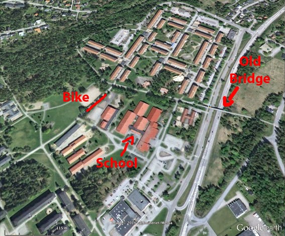
I was convinced that it was behind the school, but when I visited the place they told me that it was on the other side of the city. Coincidentally it was also the scene when the two couples talk, which I did not find before.

Now (oct.2017) I'm updating places and images of all pages of this topic

Re: Images of FA locations in Google Maps

PostPosted: Sun Oct 19, 2014 4:11 am
by Santi

Re: Images of FA locations in Google Maps

PostPosted: Sun Oct 19, 2014 6:08 am
by fish
I look forward to them Santi. :D

Re: Images of FA locations in Google Maps

PostPosted: Wed Oct 22, 2014 1:43 am
by Santi
I post all the images of (© Oddych.sk, 2002) - http://www.oddych.sk/fa/
with his permission of course, and others:
- college
- park of bike elin & johan
- Filmstudio
- agnes house, before and after the enlargement of the house
- bridge (many)
- buffet (where young people meet at night)

Some pictures are in Google maps, others not yet

Re: Images of FA locations in Google Maps

PostPosted: Wed Oct 22, 2014 8:01 am
by fish
Some of the buildings are still there, but sadly the bridge where Agnes and Elin talked was demolished a few years ago. :(

Details and pics are on the Forum somewhere. :T :lol:

Re: Images of FA locations in Google Maps

PostPosted: Wed Oct 22, 2014 9:55 am
by Ian
Sacrilege, it was. :( :wink:

Re: Images of FA locations in Google Maps

PostPosted: Wed Oct 22, 2014 3:09 pm
by Santi
I did not know. But I also put the old pictures of the house of Agnes. All will be able to see before and after all.
The Old entrance dont exist. Balcony still.
There're changes before and after in "Google Maps"

So, all images of http://www.oddych.sk/fa/


Image

Re: Images of FA locations in Google Maps

PostPosted: Wed Oct 22, 2014 3:54 pm
by Santi
I will put all images that I can. It will be nice to see in Google Maps before and after things Fucking Amal.
At least if it destroy all the things, we will have photos to remember where it happened it and how was.
(photos of before that there was Google Maps !!!)

Re: Images of FA locations in Google Maps

PostPosted: Thu Oct 23, 2014 4:47 am
by Santi

Re: Images of FA locations in Google Maps

PostPosted: Thu Oct 23, 2014 7:26 am
by fish
Oh, not half the bridge. :shock:

I can't bear it. :cry: :P :lol:

Re: Images of FA locations in Google Maps

PostPosted: Thu Oct 23, 2014 10:08 am
by Ian
Do these people have no sense of heritage?! :evil: :wink:

Re: Images of FA locations in Google Maps

PostPosted: Thu Oct 23, 2014 11:46 pm
by Santi
I have been discover that the bridge in google earth is the real bridge d'Agnes i Elin, not the new. Because the last image of satelit was in 2009, before it was demolished in 2010.
For this I went wrong

Image

Still Alive!!!!!!!
LOL!

Re: Images of FA locations in Google Maps

PostPosted: Fri Oct 24, 2014 7:19 am
by fish
If the satellite says it's still there, that's good enough for me. *:)* *:)* :lol:

Re: Images of FA locations in Google Maps

PostPosted: Fri Oct 24, 2014 9:59 am
by Ian
:shock: :shock: Can it be true?! *:)* *:)* :D

Re: Images of FA locations in Google Maps

PostPosted: Fri Oct 24, 2014 10:51 am
by Santi
look it and you will see it

Sweden's people must call to google's satellite for update (they are using old version)
LOL